
<Back
Home
Building & Construction
Railways
Urban Modelling & Landmarks
Contact
FTP Site
Samples and Downloads - A391 Project
Modeling the A391 St Austell to A30 Link Road
Cornwall County Council has invested significant amounts in the preparation of a number of major road scheme bids in recent years. One of these provides an improved link between St Austell and the A30 trunk road addressing problems of severance, congestion and road safety issues currently being experienced in the villages of Stenalees, Bugle, Lockengate and Penwithick. The scheme will be an important element in supporting and facilitating the regeneration of St Austell and the surrounding area. One of the key features in this area is disused China Clay pits and spoil heaps which the proposed road cuts straight through. The 9.km scheme it is estimated will cost £56m
In 2004 Carillion tendered for an ECI (Early Contractor Involvement), to a design produced for Cornwall County Council by Mouchel Parkman. As part of the tender Carillion produced a 1km section of road as a 3D model to both visualise the project but also to promote the use of 3D visualisation in further design assessment and public consultation.
The tender was successful and Cornwall County Council placed the contract with Carillion with spatial modelling included in the package to check and visualise the designs for project promotion and consultation both within the council and at two open day events to which the public were invited.
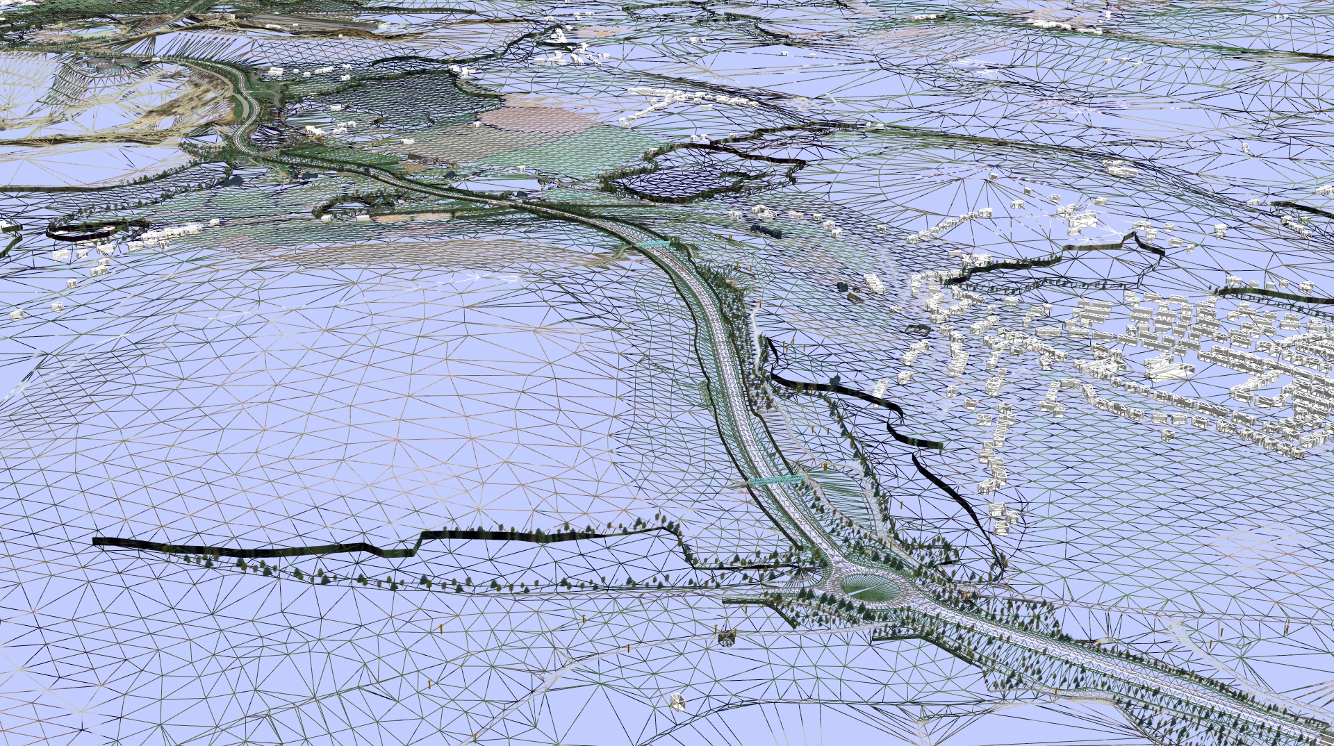
3D modelling specialist, Simon Gardiner then working on the project for Carillion describes how the model was built. “To build the underlying model we took NEXTMap Britain data and optimised the five metre DTM, to create a new TIN which uses less point data to make it more manageable. This took into account where the proposed road scheme would run ensuring a high level of detail where it was needed and less detail in the areas surrounding the new road..
The next stage was to cut the model up into 1 kilometre grid squares and apply vertical aerial photography supplied by Cornwall County Council.
Having created the basic 3D environment the next stage in the modelling process was to create a separate model derived from the detailed site survey data, which had been collected from the route of the proposed road by Mouchel Parkman. This model was then merged with the larger 3D model using ‘N4ce Survey’ software to create a complete the 3D environment with which to work. As we have seen this 3D environment is created from three separate datasets, the NEXTMap Britain DTM, aerial photography and a detailed site survey.
Once the 3D environment was complete a separate model of the actual road design was introduced. This came in the form of an MX file from Mouchel Parkman created in Bentley ‘MXRoad’ design and modelling software. This file includes road profiles, curb upstands, roundabouts verges etc. to which textures such as grass, rocks, asphalt and road markings can be applied. Further details such as trees, road signage, structures such as bridges, walls, and lastly buildings were also added. The buildings in most cases were just simple extrusions from map footprints so that individual buildings could be identified for the public consultation stage. Once this model was completed it was merged with the 3D environment to complete the full model of the scheme. The majority of the modelling was done in Autodesk 3D Studio Max, which has a wide range of lighting effects and can be used to build looping AVI movie files or fly throughs.”
The finished model can be viewed in several different ways, as a naked TIN, a coloured TIN and both before and after road completion so it is easy to see the visual impact of the new road on the landscape. From 3D Studio Max the model can be exported in a number of different file formats for use in specific software environments such as Mantra 4D. Mantra 4D is a real-time, fully immersive environment which enables the user to zoom in and out and roam at will around the complete model. This was particularly useful for the public consultation stage. The model was also used for cut and fill volume calculations to facilitate project pricing.
“When the model was completed two days of public presentations were set up in local village halls,” said Simon Gardiner. “Complete drawings of the scheme were available on presentation panels and were augmented by two computers one unmanned with a looping AVI of the model and one manned using Mantra 4D. Members of the public were able to use the model to see how the proposed route would affect them. They could view the road from their own homes and see the visual impact for themselves. The alignment of the road underwent some changes and some re-design was necessary as a result of this public consultation. The model was updated accordingly and made available to the public for further scrutiny.”
An optimised ‘myVR’ version of the A391 model will be available for viewing on the Get mapping website shortly.
To find out more about the potential of 3D modelling please contact:
Simon Gardiner
Tel: +44(0)7785 710569
Email: simon@g-vr.co.uk